Sir Eric Teichman's 1917 Track
|
The ancient Tangluo Road and Sir Eric Teichman's visit to Foping |
|
Sir Eric Teichman's 1917 Track |
|
This Page includes information and background to Sir Eric Teichman's journey from Hanzhong to
Zhouzhi across the Qinling Mountains along the ancient Tangluo Road in 1917. The page starts with a General Introduction and you could usefully
read it first. Below this there is access provided to three main types of materials:
(1) access to the KMZ file for the Tangluo Road Google Earth presentation (also available at the Main
Google Earth presentation page); READ ON! |
|
Introduction to Sir Eric Teichman and the Tangluo Road
Since pre-historic times, people have been communicating across the China’s Qingling Range. During the Qin and Han Periods (eg in Sima Qian’s "Records of the Historian") historical records of the Shu Roads started to appear. Accounts of the network of Shu Roads report that there were seven main routes. Of these there were four crossing the Qinling linking Xi’an in the Wei River Valley with the Hanzhong Basin and three linking the Hanzhong Basin with the Sichuan Basin and the destination at Chengdu. The four in the north were called (from East to West) the Ziwu Road, the Tangluo Road, the Baoxie Road and the Lianyun (Cloud linked) Road. Those in the south (from East to West) were called the Lizhi (Lychee) Road, the Micang Road and the Jinniu (Golden Ox) Road. For further information, an account of the Shu Roads is included as introduction in this web site HERE. Sir Eric Teichman was a British diplomat who travelled extensively through China and other central Asian areas between 1917 and 1943 following which he was unfortunately killed, two weeks after returning from his last journey, at the age of 60. Sir Eric wrote a number of books about his journeys, the first being "Travels of a consular officer in North West China". This book described his travels in 1917 as a Consular Officer principally to investigate the suppression of Opium cultivation under a treaty with the British Government. At the time, the Republic of China was struggling to define itself, while the west of China was being ravaged by bandits and warlord armies as well as natural enemies such as drought, famine and economic problems created by the fractured market. Starting from Tongguan and determined to ride ponies rather than walk, Sir Eric and his reluctant mounted official escort had cut across a number of old roads to reach the Hanzhong Basin at present day Ankang. They had then moved on, via historically important linking roads with a visit to the interesting Catholic mission at Guluba, before finally arriving in Hanzhong. From Hanzhong, Sir Eric decided to take his party on a very steep and difficult path across the main Taibai range of the Qinling Mountain Range to Zhouzhi in the Wei River Valley. This route basically followed an ancient Qinling Shu road called the Tangluo Road. It is this Shu Road, its history and its mountain environment that is the topic of this Web Page and its materials. You can find a description of his route extracted from his book and summarised as a resource HERE. On the way to Zhouzhi, Sir Eric visited the Administrative seat of Foping District. Foping was set in a secluded and very beautiful valley near the main divide of the Qinling range at about 1750m ASL. It was a relatively recently founded administrative centre, being established in the late Qing period in 1824 as a "Ting" or third level District. It had been founded due to the presence of extensive traffic in the area at the time and to control the banditry that preyed upon it. In 1922, five years after Sir Eric visited, the bandits won, murdering the magistrate and closing down Foping. In 1924, 100 years after it was established, the District Seat was re-instated at a new location to the east which is the present day Foping County seat. Sir Eric’s descriptions of the Qinling Roads at that time provide interesting reading. He wrote: "From Hanzhong it was our intention to re-cross the Qinling Shan back into the Wei valley. The Qinling Shan, or Nan Shan, which consist of a series of precipitous parallel ranges trending across the path of anyone travelling between south and north, have always proved an extraordinarily effective barrier to communication between the Han and Wei basins. It was this barrier which prevented the Taiping Rebellion spreading north from the Han valley into Central Shaanxi, and the Mahomedan Rebellion spreading south from the Wei valley into Southern Shaanxi; and in recent years it has kept the upper Han basin comparatively peaceful while rebellion and brigandage raged in the Wei valley and Northern Shaanxi. The Chinese have always rested content with two main routes across this barrier, one at each end; the Xi’an-Longzhuzhai road in the east [to Hubei, usually not regarded as a Shu Road], and the Fengxiang-Liuba-Hanzhong road [Lianyun Road, Main Post Road, Northern Plank Road etc] in the extreme west. There is one other route which is considered by Chinese travellers to be just passable; that south from Xi’an via Ningshan Ting [the Ziwu Road]. The remaining three routes, that in the east via Zhenan [the Kugu Road], that in the centre via Foping [the Tangluo Road], and that, further west, south from Meixian [the Baoye Road], the two latter passing over the shoulders of the Taibai Shan, one on each side, are considered by the Chinese impracticable for ordinary travellers. This is because they are too steep for chairs, and are so rough that even with mules and ponies it is necessary to do the greater portion of the journey on foot." Sir Eric was a Chinese language Scholar and recorded place names systematically using the Wade-Giles transliteration. He took bearings along the route, recorded altitudes with a pressure altimeter and estimated stage distances in Chinese Li. These make his journal a good base for representing his journey on a map or in a modern presentation system like Google Earth. However, while it is a good start, it is not an easy or straightforward exercise to carry out. This web page has been set up to provide the background to our efforts to do this, the results of our work to date and a general discussion about Sir Eric Teichman and the ancient Tangluo Road. |
|
The Ancient Qinling Tangluo Shu Road
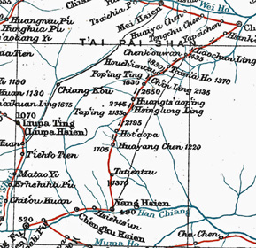
The following brief description of the ancient Tangluo Road, which started in the Wei Valley near Zhouzhi, crossed the Qinling Range and
arrived in the Han River Valley near Yangxian, was taken from:
Feng Suiping (2003). Histories of Famous Towns: Hanzhong -- the riverland of the Northwest. Sanqin Press, Xi'an. (In Chinese) Chapter 3 Shu Road Routes -- the (now) untravelled roads (Page 56)
'The Tangluo Road, like the Baoye Road, was a road that was opened up by following two rivers (one at each end of the road). In this case they were the Tang Shui (present day Tangshui River) and the Luo Shui. That is, from Zhouzhi (about 70 km west of Xi’an) it goes south along the Luo Valley, crosses over the main backbone of the Qinling Range to reach Huayang in Yangxian District, having gone effectively southwest, before finally reaching Hanzhong. This road was developed comparatively late, being first (officially) recorded in the time of Cao Shuang in the Three Kingdoms Shuhan period.
In recent years, on the basis of a passage in the "Shimen Ode": "Pushing through closed valleys, scaling the bright halls", scholars believe that the "closed valleys" and "bright halls" refer to this route. This would confirm that the Tangluo Road was already being used in the Eastern Han period. From the historical records it is clear that the period of most frequent use of this road was during the middle to later Tang Period after the Anshi Rebellion (775 CE). Because of the frequent wars in the Guanzhong, its convenient geographical position, and the need for Tang Emperors to take refuge in "Fortunate Shu", the (Tangluo) road seems to have flourished over this time.
In analysing the pluses and minuses of the various routes across the Qinling, in regard to how they link Chang'an and Hanzhong, the length of the Tangluo route is least and most direct. However, along the route you need to pass over the water divides of a number of rivers, and over steep and dangerous mountains, with rapidly changing grades along the road. The road is such that (even) present day travellers find it hard to prepare themselves and are overcome by it. Furthermore, along the route there are very few people or settlements, and there are also potentially dangerous animals and poisonous plants, so that travellers still go in fear (for their safety). The period during which the Tangluo Road was an official Postal Road was very short, and over history its general level of use has been low.'
|
|
|
Publications and Translations for the Tangluo Road
Shu Roads Book by Prof. Li Zhiqin (1986)
The most authoritative source for Shu Roads is the book by Prof Li Zhiqin et al. of the Northwest University in Xi'an:
A section introducing the Tangluo Road has been translated from Prof. Li's book and you can access a PDF of the translation HERE.
Shu Roads Paper by Zhou Zhongqing (2008)
Zhou Zhongqing of the Yangxian Museum of Hanzhong City wrote a very interesting paper about the Tangluo Road and the township of Huayang, a major centre on the road since ancient times.
The paper was published in:
This paper has been translated and you can access a PDF of the translation HERE.
Pan Wenshi's Book on the Qinling Giant Pandas (1986)
Pan Wenshi of Beijing University was Editor of a very interesting book about the Giant Pandas who have lived in this unique environment since very ancient times
and shared the Tangluo Road with people after they arrived.
The area now has two large and overlapping wildlife reserves, one is the Foping Wildlife Reserve and the other the Changqing Wildlife Reserve. Pan Wenshi's book also provides vital information
about the environment of the Tangluo Road, its geology and geomorphology as well as natural resources. This Book has a useful English Language summary at the end. It has been provided as a PDF for you to read HERE.
|
|
|
Materials and Maps for the Tangluo Road
There are three main materials being provided from this page:
(1) access to the Tangluo Road Google Earth presentation (which is also available from the
Google Earth presentation page);
The Tangluo Road Google Earth presentation KMZ file can be downloaded and viewed HERE or you can find it among the general collection of GE presentations at Google Earth KMZ Files
The above document was translated and presented at a Conference in Hanzhong in November 2013.
The collection of useful Photos, Maps, Presentations and Documents can be accessed on their own web page at:
|
|
|
Comments:
The official view has been that the Tangluo Road was relatively late to be built and only had a rather short period
in the later part of the Tang Period when it was actively being used as a main road between the Wei Valley and the
Hanzhong Basin. But the view of Zhou Zhongqing is also attractive. His view is that the Tangluo Road was probably a
very early track - even back to pre-historic times, and that it has always been in use - but possibly not
by officials and scholars - except in the later Tang Period. In response to the late appearance of the road
in classical literature he wrote:
|