The US Library of Congress Digital Chinese Map Collection
The US Library of Congress has a large collection of Chinese materials. Among these are maps and map reproductions dating back some centuries. The Geography and Map Division web page can be found HERE. Part of the collection is the Arthur Hummel collection and some of the maps of the Hummel collection are among the 287 Chinese images available in digital format. One map of interest is the “Map of the four provinces in the north bank of the Han River” 《汉江以北四省边舆图》 (1800~1820). This map is available in highest resolution as JPEG 2000 format. Since not all software can handle this format a set of Jpeg images with sizes of about 2 MB have been made available here. The resolution is sufficient to see characters almost as easily as on a higher resolution image.
The 287 Chinese Maps that are available as digital images at the US Library of Congress Geography & Map Division can be accessed directly HERE. Images can be downloaded freely for use in research and other non-profit activities in GIF, JP2 (JPEG 2000), or JPEG formats. However, only the JP2 format file has the resolution that allows view of characters at the brush stroke detail level. For academic study, high resolution view of characters is essential. If you wish to download and view the detail in these maps you will need suitable software to read JPEG 2000 and view the data. Possibly the best software available for this is IrfanView that can be downloaded from HERE. The map accessed below was converted from JPEG 2000 (jp2) to Tiff (tif) without loss and then cut into four quarters. The quarters were converted to JPEG by Adobe Photoshop with enhancement. They can now be easily viewed across the web without special software. If care is taken, a Jpeg is sufficient in this case.
List of sub-images at high resolution for the Han River North Map
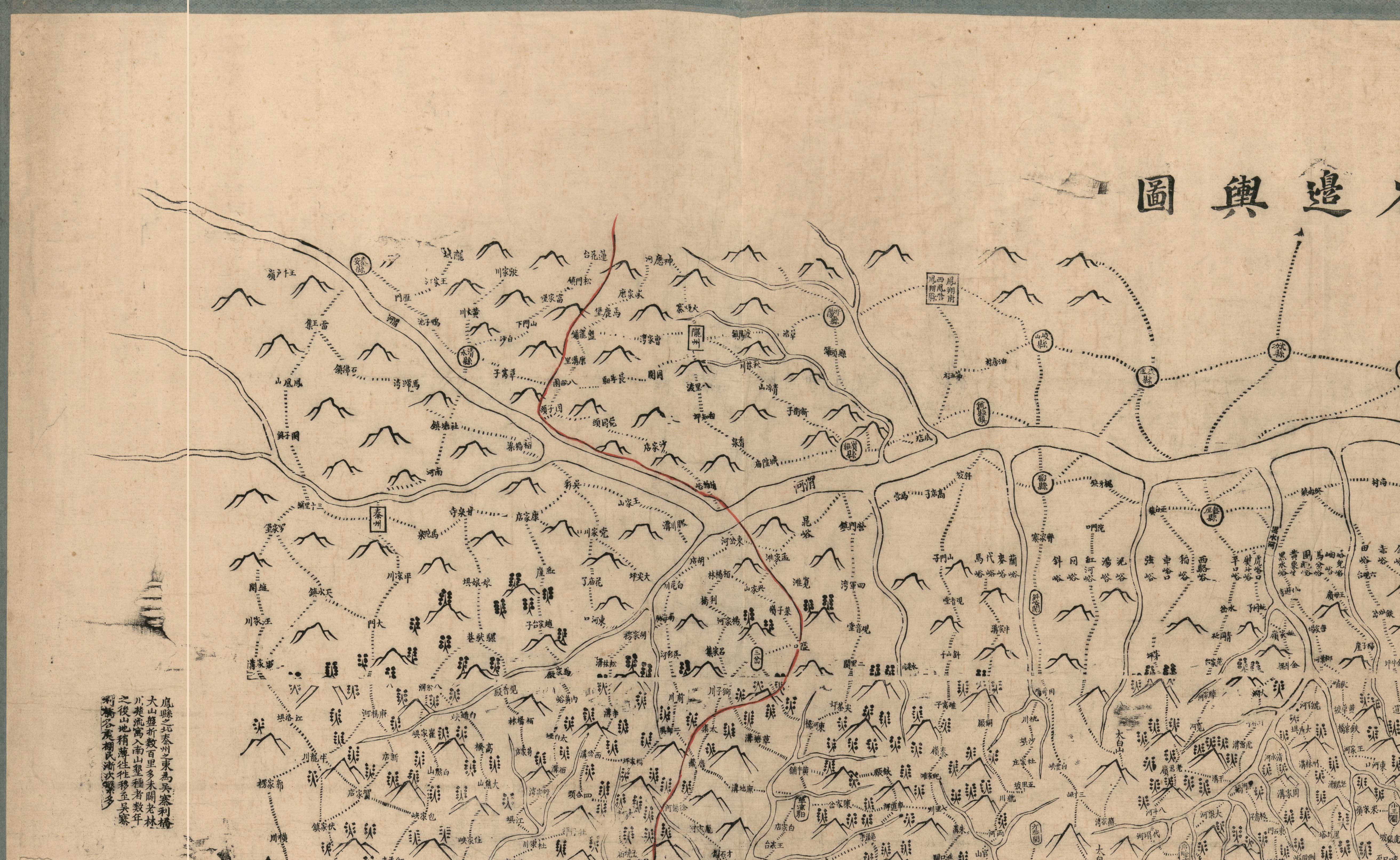
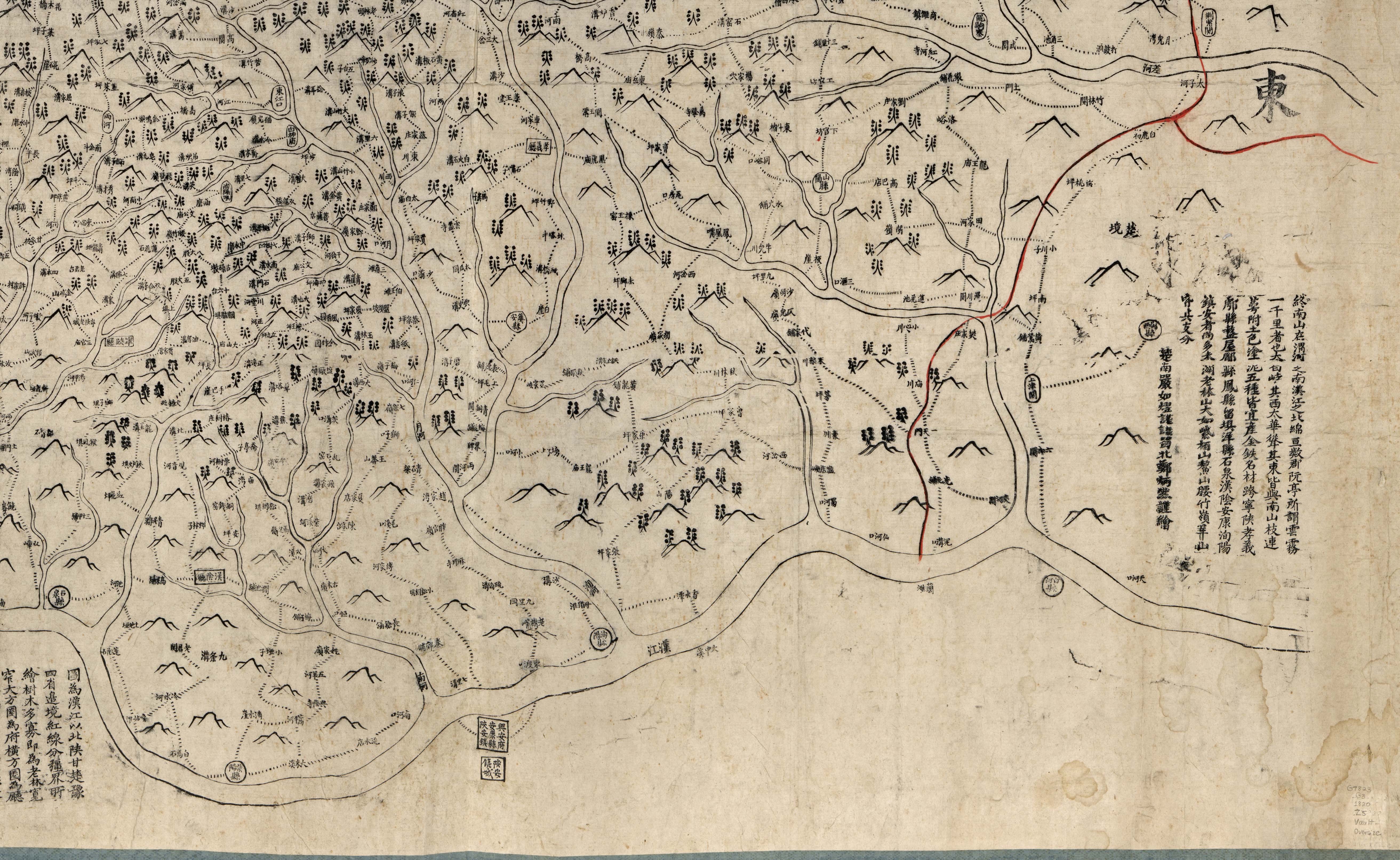
The map sections below are from the "Map of the Four Provinces on the North Bank of the Han River"
《汉江以北四省边舆图》 which part of the US Library of Congress
Collection and available as a digital image. Access is free for research or non-profit use.
The map is listed by Li Xiaocong in his book on the Hummel Collection:
Li Xiaocong (Ed) (2004). “Summaries of holdings in the US
Library of Congress' Collection of ancient Chinese maps”, Beijing, Cultural
Press, October 2004. (Chinese and English)
Meiguo Guohui Tushuguan Guancang Zhongwen Gu Ditu Xulu, Li
Xiaocong bianzhu, Beijing Wenwu Chubanshe, 2004-10.
美国国会图书馆藏中文古地图叙录,
李孝聪编著,
北京:文物出版社,
2004—10. (中英)
Entry for the map in Li Xiaocong's book:
[Translation of Chinese Text]
G7820.C5
1820
汉江以北四省边舆图
Han jiang yi bei si sheng bian yu tu
(Map of the Four Provinces on the North Bank of the Han River)
A 107 x 182 cm wood block print from the Qing Jiaqing period compiled by Yan Ruyi (Editor) and Zheng Bingran (Cartographer).
The map scale is not stated. A red signature block and Title in black ink can be found on the back.
The scope of the map covers the Han River from its source and upper reaches downstream to Baihe Xian.
To the north of the Han River it includes adjacent [watershed] areas from the four provinces of Gansu, Shaanxi, Henan and Hubei.
The brushwork depicts mountains, rivers and administrative units as well as roads and tracks of the Han River watershed.
It uses various combinations of vertical and horizontal rectangles, squares, circles and ellipses to distinguish
Prefectures, second level Ting, Zhou and Xian counties and military garrisons; it uses dotted lines to indicate roads and tracks,
and provides characters to indicate villages and towns, strategic passes and post stations along the roads;
it uses triangular symbols to indicate landforms and red lines to indicate the boundaries with the four provinces;
in mountain areas it uses symbols to indicate the presence of forests and tree density.
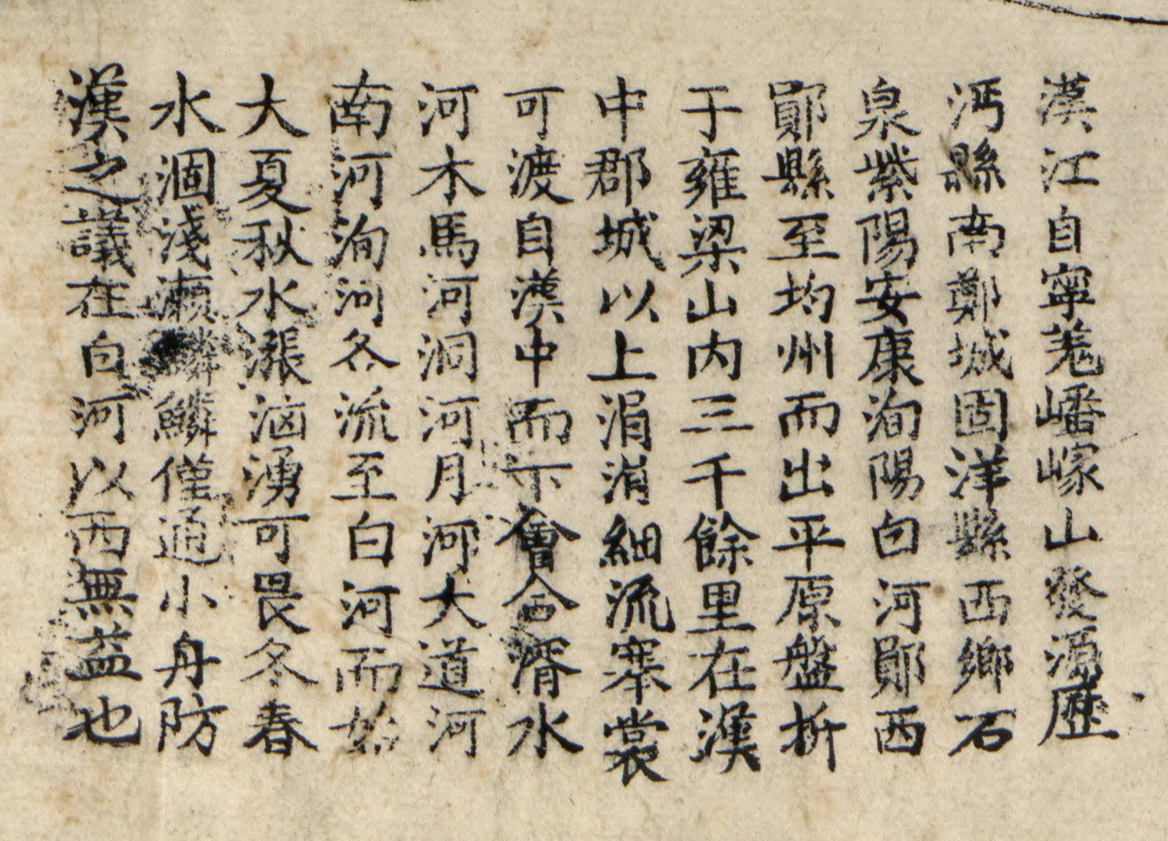
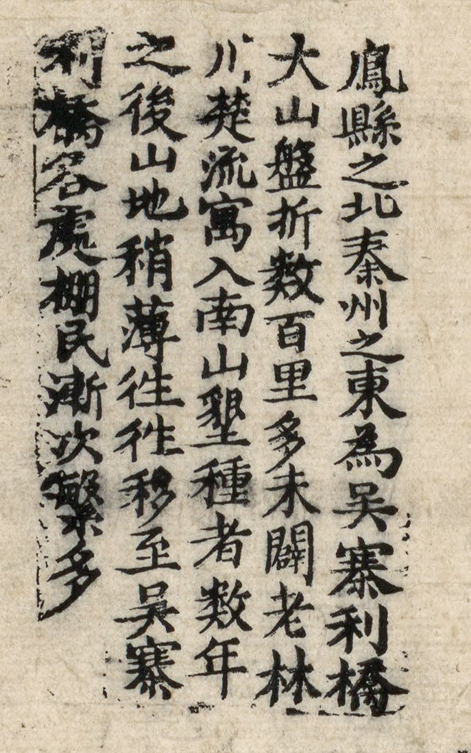
It has 6 separate annotation boxes. These provide: the legend for the annotations and symbols,
the sources and hydrology of the Han River, the main topographic features, the produce, land reclamation,
forestry, roads and situation of the settlers in the mountain areas bordering the four provinces.
Ningshaan Ting is present on the map and was established in the 5th Jiaqing year (1800) but
Foping Ting [established in 1825] is not present, and the name of Ningshaan does not indicate that the prohibition
on writing "Ning" [see Note below] was yet in force. It is therefore likely that the map was compiled in the years
between 1800 and 1820. From the annotation, it seems that this collection of materials should be combined with a
matching "Map of the Four Provinces on the South Bank of the Han River", but a second such map in the Library [of Congress]
collection was not found.
Map Series Serial Number: 84696078
[Note: Taboo on using personal names of Emperors, in this case the Daoguang Emperor whose reign years started in 1821 and who had a personal name of the same character "Ning"]
[中文]
G7820.C5
1820
汉江以北四省边舆图
(清)严如熠编,郑炳然绘,清嘉庆年间刻印本,未注比例,107×182厘米。图背贴红签,墨书图题。
此图覆盖范围从汉江上游源头至下游白河县,汉水以北的甘肃、陕西、河南、湖北四省交界地区。
以形象画法描绘汉水流域的山脉、河流、行政区划和道路。用方形、横方形、矩形、圆形和椭圆形符号,分别标示府、厅、州、县和分防、营汛的位置;用点线表示道路,注记道路沿线的村镇、关口、驿铺;用三角山形符号表示地貌,用红线标志四省分界;在部分山形符号上加标森林符号,以区别树木多寡。附6处注文,分别描述本图的编绘及图例,汉江源流及水文特征,四省境内山川形势、物产、垦殖、林木、道路及移民情况。
嘉庆五年(1800)设置的宁陕厅已标,佛坪厅未见,“宁”字不因避讳而改写。故,该图应编绘于嘉庆年间(1800~1820)。
据注文,此图应与一册描述道路程途里数的书相配合,而且还应有《汉江以南三省边舆图》合为一套,后二部图书,国会图书馆未藏。
地图部原系列号:84696078
The Jpeg map available here was developed from the original JPEG 2000 image and divided into four quarters to keep the Jpeg sizes acceptable for download (max of 2 MB). The set of six (6) annotations are also provided as details for close examination of the characters.
|
Image Number |
Jpeg Name |
Description |
|
1 |
North West Quarter of the Map |
|
|
2 |
North East Quarter of the Map |
|
|
3 |
South West Quarter of the Map |
|
|
4 |
South East Quarter of the Map |
|
|
5 |
Annotation Text 1 |
|
|
6 |
Annotation Text 2 |
|
|
7 |
Annotation Text 3 |
|
|
8 |
Annotation Text 4 |
|
|
9 |
Annotation Text 5 |
|
|
10 |
Annotation Text 6 |
NOTE 1: The images have been tested for view in Windows Explorer browser. However, despite reduction of size achieved, it is possible that the large images may not open in your browser. If this happens, you can download a image to your computer by "right clicking" on the link and using the “Save Target As…” option rather than opening it in the browser or picture viewer.
NOTE 2: If you wish to view the Jpeg image of the whole map, rather than the four quarters, it is 7.8 MB and so it has been put into a "Zip" file to force download rather than view in the browser. It will be able to be viewed by many image view software packages. To download it hit HERE.